Pictures of hundreds of large scale ice crystals broken off from the glacier, strewn on a beach were the attraction for me to this area of southeast Iceland. It was disappointing to find a couple small chunks of ice... the summer heat melted all the diamonds away. It was more annoying to me to see Chinese tourists scavenge the beach collecting little chunks of ice to place in the sand to make photos. I watched a group of 10 such tourists smiling and laughing, taking selfies and then a photo of every possible group combination that could be made from 10 people. Mathematically, the number of photo combinations that can be made from a group can be described by P(n,r)=n!(n−r)! And the time it takes to make each photo is roughly 15 seconds... this group of Chinese tourists took pictures of small ice chunks that I could’ve fabricated in my domestic freezer for an hour! All their photos were taken from the vantage of a standing person... with no thought to camera angle or layout... just a documentation of all the possible subsets of smiley people that you can create from a group. All I wanted to do was take a picture of a diamond for myself devoid of any people, showing the elemental forces that shape iceland. The Europeans stood around the Chinese, patiently placing their cameras near the sand level to make more ‘artistic’ compositions while artfully cropping out the Chinese. I took a picture of these ridiculous tourists and started walking up and down the beach.
Upstream of the beach is the translucent blue jokulsa river channel that connects the ocean to the lagoon. I saw seals bobbing their heads up and down there. There must be many fish here to support the seals. At the far side of the lagoon is the tip of a glacial tongue that extends from the Breiðamerkurjökull glacier. The portion of the glacier above waterline doesn’t appear to be that tall, but beneath the lagoon water, it extends down 300 meters making the lagoon the deepest lake in Iceland. The lagoon is comprised of icebergs, or floating masses of ice calve off the tip oh the glacial tongue, spend 5 years melting down in the lagoon small enough to float down the river and wash up on the beach to the delight of Chinese tourists.
To get up close to the iceberg and glacial wall I reserved seats on a small inflatable rubber raft with high speed motor. These boats are the fastest mode of transportation (compared to kayaking or amphibious vehicles) on the lake, able to cover the most ground. During the reservation, I thought 6:20 time would be around sunset, (I didn’t know the sun sets around 10 pm here) and I imagined a beautiful crimson sky. In reality, when I arrived at the lagoon, it was dreary and incredibly rainy... kind of like a downpour actually. My shoes became soaked as I waited in line to confirm my reservation despite using an umbrella. It seems every other tourist here got the message to bring waterproof pants and shoes except me. Wet jeans are the worst for this Iceland weather. They become cold when wet and chafe the skin. Luckily the tour offered all passengers a special astronaut suit to brave the wind and rain. So I wore the suit over my wet clothes and headed to the boats. Our tour guide told us to hold on tight. He revved the motor and headed straight towards the icebergs.
The rain stopped while we were in the middle of the lagoon. They say in Iceland, if you don’t like the weather, just wait 5 minutes. The weather is always changing. Blue is the only color that is absorbed by the ice. The form and the colors of the icebergs are amazing. Some are white and black, showing striations of basalt dust, some are iridescent blue. When the icebergs are small enough, they actually tip over... so sometimes the texture is smooth because it is the bottom of the iceberg that is exposed.
I found myself taking photos like a Chinese tourist... the tantalizing combinations of iceberg and mountains and glacial wall was too hard to resist. P(n,r)=n!(n−r)! But with extra factors to include all the Panoramas, photos and video permutations... I must’ve looked very annoying. I probably looked like a Chinese tourist to all those onboard the boat. The water splashed at the bottom of the boat at 2 C, my feet were numb, my hands were red and cold from being exposed while taking all my pictures, but the novelty of seeing these landscapes distracted me from the discomforts.
The guide then took us within a couple hundred meters of the glacial wall. This is a safe distance to view the wall since at any given moment a portion of wall could calve off creating massive waves that would overturn the boat. The guide mused that he had swam in this water twice before. He said a person could survive 5 minutes before succumbing to hypothermia. With the suits we were wearing we could survive 15 minutes if we remained still.... but he chuckled, a tourist not used to the water temperatures would flap around like a chicken and increase the flow of water through the sleeves and succumb in 5 minutes.
At the glacier wall, you could see the history of volcanic eruptions embedded in the striations of the glacial ice. On the west, the glacier was completely covered in basalt from the recent massive eruption from the relatively small volcano.......The guide then listed all the larger volcanoes in the area and said they have all been overdue for an eruption based on historical eruption cycles. One such eruption thousands of years ago was able to decimate all the redwood forests growing in southeast Iceland and replace it with desolate black basalt landscapes. Hopefully i won’t experience such a tragedy here. To Icelanders, it’s normal to live near these ticking geological time bombs. I thought being overturned in a tiny raft caused by glacier calving waves triggered by massive seismic eruptions and lava flows, flapping my body like a chicken in 2 C water only to be scorched by lava would be the most terrible way die (especially while on vacation). Hopefully it won’t happen during the tour, I thought. I took more pictures to take my mind off these imaginary catastrophes.
As we headed back to the dock, the guide pointed to a pair of large rocks (tops of large hills) in the lagoon a 100 meters from the edge of the glacial tongue. A few years ago, they were completely covered with glacial ice. Now they are exposed due to global warming. The landscapes have changed so drastically over the past thousands of years due to eruptions and ice ages but the most devastating impact may come from the hands of man.


Ascent
All the mountains here are gray, the volcano is red. It lies a couple hundred meters from town. 3/4 of the volcano blew up in a fiery rage in 1973. The lava threatened to destroy the town, but the fishermen were able to evacuate everybody to safety without Pompeii like casualties. The road to the volcano is very short.. it ends at the low side of the crater wall. A couple hundred feet up in this red gravel like material you see the entire rim. Completely blown up. Nothing is in the middle of the crater, just more red gravel, a few stray bunches of grass. I ascended to the top. There were a couple people up there when I started heading up. The sun sets super late here so it was perfect.
At the top you see verdant green hills on one side, lava flows to the ocean on another side, and the crater rim that lowers in the direction of town on another side. I couldn’t believe my luck. Good weather, sunset light making the red rocks glow even more red, contrasting to green grass mountains in the ocean and land beyond.
The wind was very strong. Like being on knife edge of Katahdin, the winds were that strong. It blew my hat down one side... I was able to recover it luckily.... when I descended it was like skiiing down gunung Batur with the danish... except red gravel instead of black.
Lava fields
“An old prophecy had said that once three specific things had happened in Vestmannaeyjar, pirates would again raid the island. Those three things were first, that the town would extend west of the landmark, Hásteinn, second, that the freshwater pool of Vilpa would no longer be in use, and third, that the son of a bishop would be ordained as a priest for the island. Early in 1973 these three things came to pass: the town extended west of Hásteinn, the Vilpa pool was filled in after the drowning there of a young child, and Karl Sigurbjörnsson, the son of a bishop (and the present bishop of Iceland) was given a position of service at the church in Vestmannaeyjar.”
January 23, 1973
Pirates in the form of lava flows and noxious gasses and spewing rocks rained down on Vestmannaeyjar. Due to stormy weather the day before, all of the island’s fishing fleet was in the harbor so that most of the inhabitants were able to be quickly. Today, on the east side of town, there is a narrow stair up a rocky mass into the red lava fields of eldfell. Just to the right of the rocky mass were the houses that were spared by the eruption. The rocky mass is 10-15 meters high.. a lava field that covered 1/3 of the town, destroying the oldest section of town. The townspeople fought valiantly against the lava by spraying it with sea water to halt its march to prevent it from filling the harbor and destroying their ocean based economy.
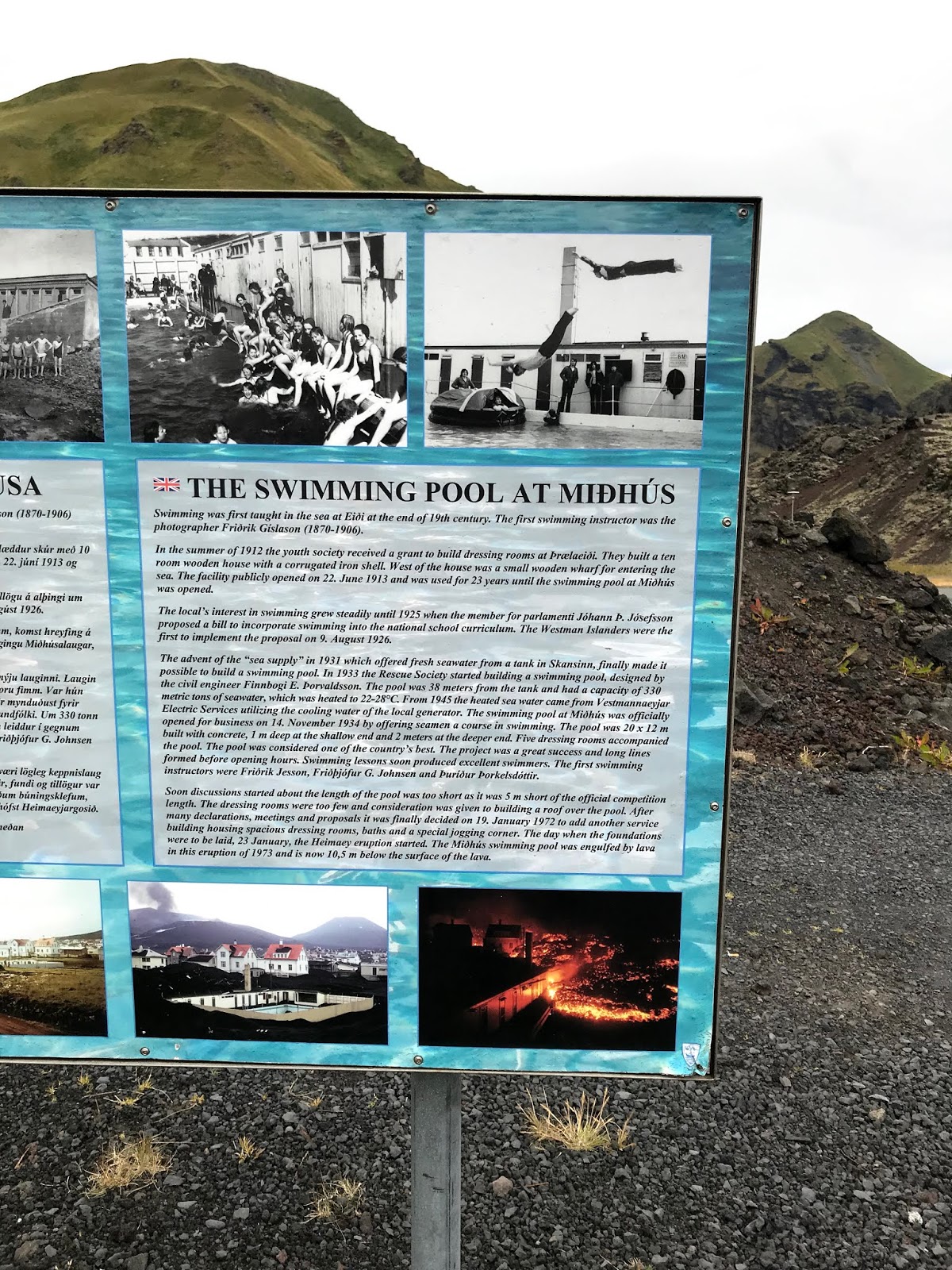
On the trail are wooden markers of streets that one stood proudly for hundreds of years. A sign showing a buried swimming pool sits like a tombstone. Plaques mounted to some igneous rocks are like grave markers that record notable historical inhabitants and buried houses below. The day before, I reached the summit of the eldfell and beheld beautiful panoramas of sunset without any memory. This morning I walked in the lava fields below that blanketed the old part town and walked on top of history and rebirth. Moss and trees have colonized the volcanic rocks creating the typical Bjork Icelandic landscape. Soft, rugged, unpredictable, elemental, and growing out of the harshest conditions. Many residents did not return after the eruption... too traumatized by the events. New people arrived and rebuilt the town... like new moss colonizing the lava rocks... another layer of history on this island.